
On March 4, 1863, President Abraham Lincoln signed an act creating Idaho Territory from portions of Washington and Dakota Territories and placed the capital at Lewiston. The original Idaho Territory included most of the areas that later became the states of Idaho, Montana and Wyoming with a population of less than 17,000. In 1868, Idaho Territory took the size and shape of what would become the State Of Idaho which was admitted to the Union in 1890.
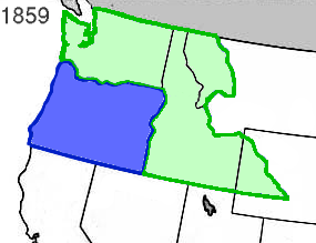
A big chunk of the Pacific Northwest was known as Washington and Oregon Territories in 1853. In 1859 Oregon was made a state and Washington Territory was expanded.

In the early 1860's gold was being discovered in what we now know as the Sawtooth Mountains of Idaho and Montana. With more claims made, towns founded and people migrating to the area, it was determined that trying to govern the area from the Territorial Capitol of Olympia was impossible, there needed to be a more local seat and Idaho Territory was created with the capitol in Lewiston. Lewiston being a major trade center and supply head for much of the mining efforts.
A big chunk of the Pacific Northwest was known as Washington and Oregon Territories in 1853. In 1859 Oregon was made a state and Washington Territory was expanded.
In the early 1860's gold was being discovered in what we now know as the Sawtooth Mountains of Idaho and Montana. With more claims made, towns founded and people migrating to the area, it was determined that trying to govern the area from the Territorial Capitol of Olympia was impossible, there needed to be a more local seat and Idaho Territory was created with the capitol in Lewiston. Lewiston being a major trade center and supply head for much of the mining efforts.
When Idaho Territory was created by act of congress, March 3, it covered 326,373 square miles between the 104th and 117th meridian, and the 42nd and the 49th parallels of latitude. It extended to within fifty miles of the Missouri River below the mouth of the Yellowstone River, and included the Milk, White Earth, Big Horn and Powder Rivers. Within Idaho Territory were the Black Hills, Fort Laramie, Long's Peak, the South Pass, Green River, Fort Hall, Fort Boise and the trail routes of settlers going to the Pacific coast along Snake River. Idaho Territory also included all of what is now Montana and a large portion of what became Wyoming.
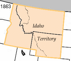
The Idaho Territorial lines, according to the act of March 3, 1863, were defined as:
Beginning at a point in the middle of the channel of the Snake River where the northern boundary of Oregon intersects the same, thence following down said channel of the Snake River to a point opposite the mouth of the Kooskooskia or Clearwater River, thence due north to the forty-ninth parallel of latitude, thence east along said parallel to the twenty-seventh degree of longitude west of Washington, thence south along said degree of longitude to the northern boundary of Colorado territory, thence west along said boundary to the thirty-third degree of longitude west of Washington, thence north along said degree of longitude to the forty-second parallel of latitude, thence west along said parallel to the eastern boundary of the state of Oregon, thence north along said boundary to the place of beginning.
Keep checking in as we continue to post more history, information and points of interest in North Idaho. On July 3 we'll mark 120 years since statehood.


 Posts
Posts

