Wednesday, March 24, 2010

Idaho State Fossil?

Idaho has an official State Fossil?  Yes, it's true.  Idaho has declared a number of official items.  Sure you knew the State Bird is the Mountain Bluebird and the State flower is the Syringa, but did you know Idaho also has a State Insect, Raptor, Dance, Soil and even Fossil.

The 1988 legislature designated the Hagerman Horse as the Official State Fossil. Discovered in 1928, it was originally described as Plesippus shoshonensis. The Hagerman Horse is the oldest known representative of the modern horse genus Equus (includes horses, donkeys, and zebras) and is believed to be more closely related to the living Grevy's zebra in Africa.


Just so you won't get caught not knowing this information, here's the official list for the State of Idaho.


State flower is the Syringa
State bird is the Mountain Bluebird
State tree is the Western White Pine.
State fruit is the Huckleberry
State vegetable is the Potato
State horse is the Appaloosa
State fish is the Cutthroat Trout
State insect is the Monarch Butterfly
State gem is the Star Garnet
State fossil is the Hagerman Horse
State raptor is the Peregrine Falcon
State dance is the Square Dance
State soil is Threebear

Perhaps we should also have an official State Pie, Huckleberry of course.

(Just so you'll know, Threebear consists of moderately well drained soils formed in silty sediments with a thick mantle of volcanic ash.)

Friday, March 19, 2010

Born in the Iron Horse Parking Lot

Seriously.  There are lots of people who where born in the Iron Horse Parking lot at 4th & Lakeside in Coeur d'Alene.  Of course it wasn't a parking lot then, it was Lake City General Hospital.


Lake City General was a three story building with 36 beds and was at one time was considered on the cutting edge of medicine.  It wasn't unusual to have North Idaho's inured loggers sent there for treatment.  And countless babies were born at Lake City General.


Lake City was closed November 1966 when Kootenai Memorial Hospital (Kootenai medical Center, Kootenai Health) was opened at the I-90 and Hwy 95 junction.  And that's why there was an era when every kid in Coeur d'Alene who had a bicycle knew where Hospital Hills were.  But that's anther story for another blog.


After it ceased being a hospital a man named Francis Schuckhardt acquired the use of, and perhaps ownership of, the LCGH building.  Schuckhardt had risen to a top administrative position with the Blue Army a mainstream Catholic Marian organization but was dismissed in 1966 for condemning a Vatican Council.  The following year he founded a militarily traditionalist community in Coeur d'Alene called the Fatima Crusade which was housed in the old hospital.  Later the name was changed to the Tridentine Latin Rite Church.  


Locals still referred to the group as the Blue Army due to the blue habits the nuns wore.  And there a lot of them.  They traveled around in big white vans full of praying nuns.  A local inside joke was they were praying they wouldn't get in a wreck because it looked like even the driver was praying instead of driving.


Followers of Schuckhardt came to the area and started a community, The City of Mary, near Rathdrum.  By the mid 1970's the whole operation was moved to Mount St. Michael's outside of Spokane.


The hospital then became the home of a new company called Action Printers.  As it grew, Action Printers moved out and the building was acquired by Tom Robb of the Iron Horse, leveled and turned into the current parking lot.


So next time you hear someone say "I was born in the Iron Horse parking lot" you better believe them.

Thursday, March 18, 2010

This Day in Idaho History, 18 March 1859


March 18, 1859 The United States War Department appropriates $100,000 for the actual construction of what would be known as the Mullan Road.


As early as 1852 proposals were made to build a railroad to the Pacific and many routes were considered.  One was a northern route from the Great Lakes to Puget Sound.  In 1853, Washington Territorial Governor General Issac Stevens was ordered by Congress to find a possible route from the Missouri River to the Columbia River.  One of those in that exploration party was Lt. John Mullan.

In 1854 Congress appointed Mullan to survey a route between Ft. Benton (MT) to Ft. Walla Walla (WA).  Mullan and his team crossed the Continental Divide six times and traveled over a thousand miles picking the best route.  In 1855 Mullan went to Washington, DC to make his report and secure funding.  Politicians favoring a southern route and lack of money held it up until 1857.

The threat of Indians in the eastern part of Washington Territory spurred Congress to action and directed Mullan to make a final survey and make plans for construction.  Mullan refined the survey and served as topographer while a member of Col  George Wright's forces when they fought the Nez Perce, Spokane, Coeur d'Alene, Palouse and Yakima tribes.  

Finally in 1859, March 18th, funds were allocated for the road's construction.  On July 1 Mullan started the road work in Walla Walla.  Completed in 1862, the "Mullan Road" was passed over for the route of the first transcontinental railroad (though the northern route was later used) but became a major road for settlers and prospectors.

General William T. Sherman crossed the road in 1877 on a tour to locate possible forts.  It was on that trip that Sherman picked the site for Fort Coeur d'Alene.  Later the name was changed to Ft. Sherman and that site is now the home of North Idaho College.


Interstate 90 follows Mullan's road.


Tuesday, March 9, 2010

This Day in History, March 9


1900    Fort Sherman officially terminated
Established in 1878 at Camp Coeur d'Alene, on March 9, 1900, Fort Sherman was officially closed.  Fort Coeur d'Alene was never much of a military presence but more of an outpost.  By the time it was built "indian problems" had ended with the defeat of Chief Joseph and the Nez Perce in 1877. 
The first time troops were sent from Ft. Sherman was in 1892 when conflicts between mine owners and labor unions erupted in the Silver Valley to uphold martial law.   Most of the garrison was moved to Ft. George Wright in Spokane in 1895.  the last deployment from Ft. Sherman was sending troops to the Spanish American War in 1898. 

While General William Tecumseh Sherman certainly picked a picturesque location, high spring waters occasionally flooded the fort, the worst in 1894.  The surrounding area grew into a town and the lakes and rivers became trade routes and tourist destinations.  Nice place, but not for a military fort.

Friday, March 5, 2010

The Great Seal of the State of Idaho, Part 2

March 5, 1891, Emma Edwards Green was handed the honorarium by Governor Norman B. Willey for designing the Great Seal of the State of Idaho.  

 
Idaho became a state on July 3, 1890 and that summer a young woman came to Boise to visit relatives.  Emma Sarah Etine Edwards, who was the daughter of John C. Edwards, a former Governor of Missouri (1844-48).

Emma, the oldest of eight children, was well educated for a woman of that time.  She stopped in Boise on her way home from New York where she had spent a year at art school.  She was intending on a short stay but fell in love with the area and stayed.  Emma went on to start art classes where she taught locals to paint.

She was invited to enter a design for the Great Seal of the State of Idaho.  The First Legislature passed Concurrent Resolution No. 1 which offered a prize of one hundred dollars for the best design submitted.

Artists from all over the country entered, but the unanimous winner was Emma Edwards, who became the first and only woman to design a Great Seal of a State.  Later she married miner James G. Green.  Emma died in Boise on January 6, 1942.


Thursday, March 4, 2010

This Day in Idaho History, March 4, 1863, Idaho Territory

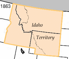
On March 4, 1863, President Abraham Lincoln signed an act creating Idaho Territory from portions of Washington and Dakota Territories and placed the capital at Lewiston.  The original Idaho Territory included most of the areas that later became the states of Idaho, Montana and Wyoming with a population of less than 17,000.   In 1868, Idaho Territory took the size and shape of what would become the State Of Idaho which was admitted to the Union in 1890.

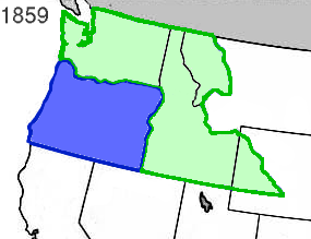
A big chunk of the Pacific Northwest was known as Washington and Oregon Territories in 1853.  In 1859 Oregon was made a state and Washington Territory was expanded.


In the early 1860's gold was being discovered in what we now know as the Sawtooth Mountains of Idaho and Montana.  With more claims made, towns founded and people migrating to the area, it was determined that trying to govern the area from the Territorial Capitol of Olympia was impossible, there needed to be a more local seat and Idaho Territory was created with the capitol in Lewiston.  Lewiston being a major trade center and supply head for much of the mining efforts.

When Idaho Territory was created by act of congress, March 3, it covered 326,373 square miles between the 104th and 117th meridian, and the 42nd and the 49th parallels of latitude.  It extended to within fifty miles of the Missouri River below the mouth of the Yellowstone River, and included the Milk, White Earth, Big Horn and Powder Rivers.  Within Idaho Territory were the Black Hills, Fort Laramie, Long's Peak, the South Pass, Green River, Fort Hall, Fort Boise and the trail routes of settlers going to the Pacific coast along Snake River.  Idaho Territory also included all of what is now Montana and a large portion of what became Wyoming. 


The Idaho Territorial lines, according to the act of March 3, 1863, were defined as:

Beginning at a point in the middle of the channel of the Snake River where the northern boundary of Oregon intersects the same, thence following down said channel of the Snake River to a point opposite the mouth of the Kooskooskia or Clearwater River, thence due north to the forty-ninth parallel of latitude, thence east along said parallel to the twenty-seventh degree of longitude west of Washington, thence south along said degree of longitude to the northern boundary of Colorado territory, thence west along said boundary to the thirty-third degree of longitude west of Washington, thence north along said degree of longitude to the forty-second parallel of latitude, thence west along said parallel to the eastern boundary of the state of Oregon, thence north along said boundary to the place of beginning.

Keep checking in as we continue to post more history, information and points of interest in North Idaho.  On July 3 we'll mark 120 years since statehood.

Wednesday, March 3, 2010

This Day in North Idaho History, March 3, 1934

March 3, 1934, second version of the Long Bridge connecting Sandpoint and Sagle is dedicated.


The first bridge to span Lake Pend Oreille was built in 1908 and lasted 25 years.  The next bridge construction was a project of the WPA, Works Project Administration at a cost of $160,000.  The bridge was just short of 2 miles and was known for years as the world's longest wooden bridge.

Construction wasn't without problems.  Five thousand pounds of steel to be used for girders was dropped into 20 feet of water at Dover when the boom being used to load it onto a barge broke.

The fourth and current bridge was completed in 1981.  The third bridge is next to the main one and is now used by walkers, runners and bicyclists.

The Long Bridge is also the site of the Long Bridge Swim the first Saturday in August.

Monday, March 1, 2010

This Day in Idaho History, Feb 27-28

Snowslides at Mace and Burke kill over 20 and destroy Carbondale Hill Mining Co

February 27-28, 1910

The Mace slide from Custer Peak hit at 10:35pm and went through the town and up the opposite slope.  The canyon was filled with 45 feet of snow.  A construction train was tossed from the track into a ravine and those on board had to dig their way out.  By shear luck, the slide missed the Standard Mine boarding house, where 300 miners were sleeping, by 120 feet.  


Old timers in the region had been warning of slides due to the record snows and recent Chinook winds and rain.  When word of the Mace slide got to Burke it caused a near evacuation of Burke, most likely saving many lives when a slide hit town at 5:30am.  


The Burke slide was 3,000 feet long and filled the canyon, burying Burke under 50 feet of snow.  It took up to 8-10 hours to dig survivors out.