Showing posts with label history. Show all posts

Friday, March 5, 2010

The Great Seal of the State of Idaho, Part 2

March 5, 1891, Emma Edwards Green was handed the honorarium by Governor Norman B. Willey for designing the Great Seal of the State of Idaho.  

 
Idaho became a state on July 3, 1890 and that summer a young woman came to Boise to visit relatives.  Emma Sarah Etine Edwards, who was the daughter of John C. Edwards, a former Governor of Missouri (1844-48).

Emma, the oldest of eight children, was well educated for a woman of that time.  She stopped in Boise on her way home from New York where she had spent a year at art school.  She was intending on a short stay but fell in love with the area and stayed.  Emma went on to start art classes where she taught locals to paint.

She was invited to enter a design for the Great Seal of the State of Idaho.  The First Legislature passed Concurrent Resolution No. 1 which offered a prize of one hundred dollars for the best design submitted.

Artists from all over the country entered, but the unanimous winner was Emma Edwards, who became the first and only woman to design a Great Seal of a State.  Later she married miner James G. Green.  Emma died in Boise on January 6, 1942.


Thursday, March 4, 2010

This Day in Idaho History, March 4, 1863, Idaho Territory

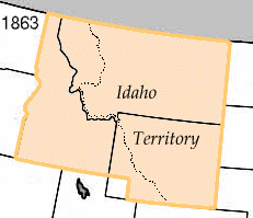
On March 4, 1863, President Abraham Lincoln signed an act creating Idaho Territory from portions of Washington and Dakota Territories and placed the capital at Lewiston.  The original Idaho Territory included most of the areas that later became the states of Idaho, Montana and Wyoming with a population of less than 17,000.   In 1868, Idaho Territory took the size and shape of what would become the State Of Idaho which was admitted to the Union in 1890.

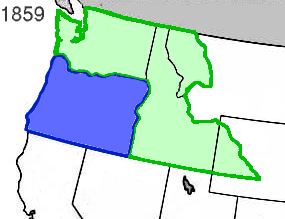
A big chunk of the Pacific Northwest was known as Washington and Oregon Territories in 1853.  In 1859 Oregon was made a state and Washington Territory was expanded.


In the early 1860's gold was being discovered in what we now know as the Sawtooth Mountains of Idaho and Montana.  With more claims made, towns founded and people migrating to the area, it was determined that trying to govern the area from the Territorial Capitol of Olympia was impossible, there needed to be a more local seat and Idaho Territory was created with the capitol in Lewiston.  Lewiston being a major trade center and supply head for much of the mining efforts.

When Idaho Territory was created by act of congress, March 3, it covered 326,373 square miles between the 104th and 117th meridian, and the 42nd and the 49th parallels of latitude.  It extended to within fifty miles of the Missouri River below the mouth of the Yellowstone River, and included the Milk, White Earth, Big Horn and Powder Rivers.  Within Idaho Territory were the Black Hills, Fort Laramie, Long's Peak, the South Pass, Green River, Fort Hall, Fort Boise and the trail routes of settlers going to the Pacific coast along Snake River.  Idaho Territory also included all of what is now Montana and a large portion of what became Wyoming. 


The Idaho Territorial lines, according to the act of March 3, 1863, were defined as:

Beginning at a point in the middle of the channel of the Snake River where the northern boundary of Oregon intersects the same, thence following down said channel of the Snake River to a point opposite the mouth of the Kooskooskia or Clearwater River, thence due north to the forty-ninth parallel of latitude, thence east along said parallel to the twenty-seventh degree of longitude west of Washington, thence south along said degree of longitude to the northern boundary of Colorado territory, thence west along said boundary to the thirty-third degree of longitude west of Washington, thence north along said degree of longitude to the forty-second parallel of latitude, thence west along said parallel to the eastern boundary of the state of Oregon, thence north along said boundary to the place of beginning.

Keep checking in as we continue to post more history, information and points of interest in North Idaho.  On July 3 we'll mark 120 years since statehood.

Wednesday, March 3, 2010

This Day in North Idaho History, March 3, 1934

March 3, 1934, second version of the Long Bridge connecting Sandpoint and Sagle is dedicated.


The first bridge to span Lake Pend Oreille was built in 1908 and lasted 25 years.  The next bridge construction was a project of the WPA, Works Project Administration at a cost of $160,000.  The bridge was just short of 2 miles and was known for years as the world's longest wooden bridge.

Construction wasn't without problems.  Five thousand pounds of steel to be used for girders was dropped into 20 feet of water at Dover when the boom being used to load it onto a barge broke.

The fourth and current bridge was completed in 1981.  The third bridge is next to the main one and is now used by walkers, runners and bicyclists.

The Long Bridge is also the site of the Long Bridge Swim the first Saturday in August.

Monday, March 1, 2010

This Day in Idaho History, Feb 27-28

Snowslides at Mace and Burke kill over 20 and destroy Carbondale Hill Mining Co

February 27-28, 1910

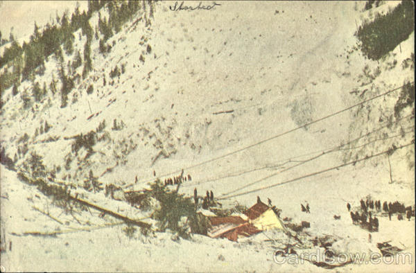
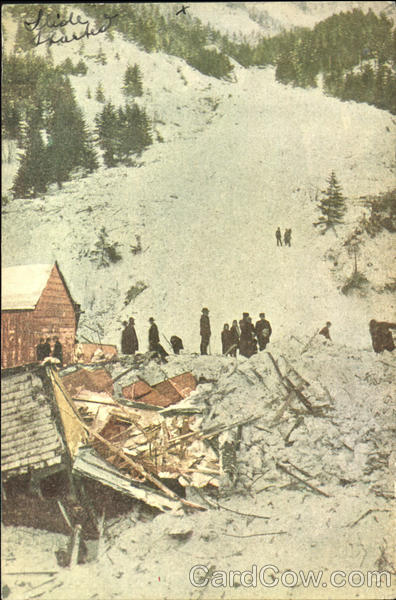
The Mace slide from Custer Peak hit at 10:35pm and went through the town and up the opposite slope.  The canyon was filled with 45 feet of snow.  A construction train was tossed from the track into a ravine and those on board had to dig their way out.  By shear luck, the slide missed the Standard Mine boarding house, where 300 miners were sleeping, by 120 feet.  


Old timers in the region had been warning of slides due to the record snows and recent Chinook winds and rain.  When word of the Mace slide got to Burke it caused a near evacuation of Burke, most likely saving many lives when a slide hit town at 5:30am.  


The Burke slide was 3,000 feet long and filled the canyon, burying Burke under 50 feet of snow.  It took up to 8-10 hours to dig survivors out.

Thursday, February 25, 2010

The Great Seal of Idaho

There is no official record of when the first Great Seal of Idaho was adopted when Idaho was declared a territory in 1863.  This is that first seal, the design credited to Silas D. Cochran, a clerk in the office of the Secretary of State.


There was dissatisfaction with this official seal and Territorial Governor Caleb Lyon presented a seal of his own design which was accepted by the Idaho Territorial Legislature on January 11, 1866.  This Seal (below) was redrawn a number of times but was used until Idaho became a state in 1890.

In March, 1891, the basis for the current Great Seal of the State of Idaho was adopted and is a story in itself as it was the only State Seal that was designed by a woman.  Check back here for more on the story to be continued on March 5 and March 14.

Friday, February 19, 2010

The Military Connection to North Idaho

Last night was Part 6 of the 12 part Connections to the Past history series presented by Robert Singletary at the CdA Library and focused on our military connection.  Here's a few interesting bits of information.


General William T. Sherman, the Union Civil War hero and Confederate scoundrel who marched through Georgia, was on an inspedtion tour and followed the Mullan Road.  Impressed with the location where the Spokane River flows out of Coeur d'Alene Lake he recommended it as a site for a fort. On April 16, 1878, a military post known as Camp Coeur d’Alene was established. The name was changed to Fort Coeur d’Alene on April 5, 1879, and finally to Fort Sherman, April 6, 1887.

The Army's 2nd Infantry Unit was the first to man Fort Coeur d'Alene and grudgingly helped build the encampment.  The last regular unit to be stationed was the 16th Infantry between 1894 and 1898.

Post Civil War, soldiers quit the military and tried to resume their regular lives.  The Army was hard pressed to recruit and many immigrants were accepted to build back the forces.  Many soldier couldn't even speak English and, like many forts, Fort Coeur d'Alene had English classes for the troops.

The Fort CdA/Sherman hospital was one of the finest in the Inland Northwest and many military personnel were sent there for treatment.  The hospital was also required to keep weather records, that's why local weather can be tracked back that far.

A town was built around the fort as non-military people were required to provide goods and services, from construction to food to local women who washed uniforms.  Soldiers referred to the area we now call City Beach as Sudstown because that's where clothes were washed on rocks in the lake.

Oscar Canfield was a friend of Sherman's and got the first contract to supply beef to the fort.  Visiting the ranch, Sherman asked what the name of the mountain behind them was called.  Previously unnamed, Sherman declared it to be Canfield.

Other place names also originated from these times.  One commanding officer was Col. William P. Carlin, another Civil War hero who led the troops in the mining revolt of 1890.  He wasn't very fond of the post but did end up buying property on the east side of the lake, now known as Carlin Bay.  Some of the soldiers who mustered out of the Army stayed and homesteaded the area, one was a Col. Stanley, hence Stanley Hill.

Over time, Fort Sherman was pinched in as a town had grown around it and due to the fact it was susceptible to spring flooding, it was decommissioned and troops were moved to Ft. George Wright in Spokane in April of 1901.  The area was turned over to the Department of the Interior and was sold at public auction in 1905.

This history series is entertaining and enlightening, as are a number of other presentations at North Idaho libraries.  To see what's coming up, visit FYI North Idaho and check the calendar of events.

Tuesday, February 9, 2010

This Day in Idaho History, Feb 10

February 10, 1881 Historical Society of Idaho Pioneers forms to collect and preserve a reliable history of the early settlement of the territory.


Idaho is chock full of history. Thank goodness these pioneers chose to get things started.  You can visit the official website  at  http://www.idahohistory.net/

Monday, February 8, 2010

On This Day in Idaho History, Feb 8

February 8, 1921: Movie star Lana (Julia Jean) Turner born in Wallace


Born Julia Jean Mildred Frances Turner in Wallace, Idaho, she was the daughter of John Virgil Turner, a miner from Tennessee, and Mildred Frances Cowan, a sixteen-year-old Alabama native.


Until her film career took off, she was known to family and friends as "Judy". Hard times eventually forced the family to re-locate to San Francisco, where her parents soon separated.

Turner's discovery at a Hollywood drug store is a show-business legend. As a sixteen-year-old student at Hollywood High School, Turner skipped a typing class and bought a Coke at the Top Hat Cafe where she was spotted by William Wilkerson, publisher of The Hollywood Reporter.  Wilkerson was attracted by her beauty and physique, and referred her to actor/comedian/talent agent Zeppo Marx.  Marx's agency immediately signed her to a contract.

And the rest, they say, is history.

Tuesday, January 19, 2010

Native American Connection to the Past

In case you missed the first session last week, here's a brief recap.  There is a wonderful series on local history that started last week and continues through April.  These 2 hour presentations by historian Robert Singletary are held at the CdA Library and are free of charge and open to the public.  For more information check out http://www.cdalibrary.org/.

Last week was the opener and focused on the Native American connection.  Here's a very brief overview of some of the things discussed that night.

The term reservation comes from a proclamation made in 1763 where a line was drawn "reserving" land for the Indians.  Of course, over the decades these lines were moved, changed and even eliminated as the United States expanded.  Many of these changes were made to exploit natural resources.  As an example, when gold was discovered at what is now known as Orofino (Spanish for "fine gold") the size of the Nez Perce Reservation was dramatically reduced.

The fur trade was one of the most valuable businesses in America and it was trappers and traders who first made their way through this area.  Many of these men were Christians and bore a cross.  Indians were curious and wanted to know more about the religion of the white man.  Flatheads made four trips to St. Louis in the 1930's to ask for a "Blackrobe" to come and teach Christianity.  But it was the Protestant missionaries Spaulding and Whitman who beat the Catholics into Idaho in 1835-36.

The advent of horses allowed the tribes to travel to hunt and trade.  It wasn't unusual to have these missions last 2-3 years.  The Coeur d'Alene, Nez Perce and Kootenai tribes were known to travel as far as the plains to hunt buffalo.

After Custer's defeat at Bighorn the government made efforts to move the Nez Perce to a reservation.  The story of how Chief Joseph led the Nez Perce on a sojourn to Canada, only to be captured short of their goal in north central Montana and moved to Oklahoma is worthy of any interested in this history.

Army Col. George Wright was assigned to solve the "Indian problem" in these territories.  One notable act was the systematic slaughter of Spokan Tribe horses at the present location of the Washington Port of Entry is at the Idaho Washington state line.  A stone monument still stands adjacent to the rest area.

The name Qualchan (Golf Course in Spokane) refers to from Qualchan (son of Yakama Chief Owhi) who had carried out raid on settlers and prospectors.  Hangman Creek is named from where Col. George Wright had Qualchan hung within 15 minutes of arriving at his camp.

This is just a small taste of what Mr. Singletary presented in this first of 12 evenings.  Don't miss the next Connections session this Thursday night.  The topic is Lewis & Clark.

Monday, January 11, 2010

This Day in North Idaho History, Jan 12

1907 Act drafted to create Bonner County from the northern part of Kootenai County

Kootenai was a very large county (see Jan 9) and it led to discussion of dividing it up to manage jurisdiction and cut the time and expense of court cases due to the distances people had to travel.  On January 12, 1907, an act to create and organize Bonner County from the northern part of Kootenai County was drafted and introduced by State Representative Taylor.  The bill passed the House and Senate without opposition.

Tuesday, January 5, 2010

This Day in Idaho History, 5 January

January 5, 1908, citizens meet to discuss the incorporation of Spirit Lake as a town.

Prior to the white man's arrival, Native Americans named the lake Tesemini meaning Lake of Spirits.  Legend has it that the daughter of a Chief eloped with a brave against her father's wishes.  Rather than risk being taken and separated, the young lovers jumped from a high cliff into the lake.  The legend says their bodies were never found because the lake spirit had carried them away.

Monday, December 28, 2009

28 December in Idaho History

1903    First Coeur d'Alene & Spokane Railway electric line train arrives in Coeur d'Alene

D.C. Corbin and associates created the Coeur d'Alene Railway and Navigation Company in 1886 with the backing of the Northern Pacific Railway.  Corbin's plans included two lines, the first was a branch line from the NP main line at Hauser Junction through Post Falls and on to Coeur d'Alene where it would connect with the steamboats.  This was the first railway in Coeur d'Alene.

In 1902 the Coeur d'Alene & Spokane Railway Company was started by lumberman F.A. Blackwell and banker Wiliam Dollar and planned an electric interurban railay btween the two growing towns.  On December 28, 1903 the first electric line train arrived in Coeur d'Alene and was greeted by hundreds of people.
The "electric line" was a pivitol key in the development of Coeur d'Alene as a tourist destination.  The line became very popular, especially in summer months as tourists combined the rail trip with a steamboat excursion on the lake.  In July of 1907, over 100,000 passengers made the trip from Spokane.

Tuesday, December 22, 2009

December 22 in Idaho History

December 22, 1864:  The second Legislature of Idaho Territory creates Kootenai County from the north end of Nez Perce County.

What is now Kootenai County was one considered part of Oregon Country (1803-1848), Oregon territory (1848-1853), Washington Territory (1853-1863), Idaho Territory (1863-1890) and finally Idaho when we became a state in 1890.

The original boundaries of Kootenai County were above the 48th Parallel, bordering present day Washington on the west, Montana on the wast and Canada on the north.  Of note is the present Kootenai County was not included, now located south of the 48th Parallel.

The original county seat was Senaquoteen, a small trading post located on the south shore of the Clark Fork River and later changed to Pend Oreille opposite the present town of Laclede. At the time Seaquoteen was the only settlement in Idaho territory north of Lewiston.  All that remains is an old graveyard.

Stay tuned for more history, trivia and legends about North Idaho.

Tuesday, December 15, 2009

December 15 in Idaho History, Shoshone County

December 15, 1861:  Shoshone County created.

Shoshone County was officialy established on February 4, 1864 with its county seat in Pierce, Idaho. Today, Pierce, Idaho is located in neighboring country, Clearwater County.  In 1885, the county seat was moved to Murray at the height of the gold rush there.  It was later moved to Osborn (now spelled Osburn) in 1890.  In 1893, it was moved to its current location of Wallace, Idaho.  Shoshone County was named after the Shoshoni Indian tribe.

The land area of Shoshone County is 2,640 square miles, approximately 640 square miles larger than the states of Delaware and Rhode Island.  The population of this large county is small; the 2000 census indicated only 13,771 people lived there with an average of five people for every square mile.  The tallest mountain in the area, Stevens Peak, is located south of Mullan and is approximately 7,000 feet in height.

The photo above points to the known center of the universe at 6th & Bank Streets in Wallace.  OK, actually it's just a manhole cover.  But for all we know....